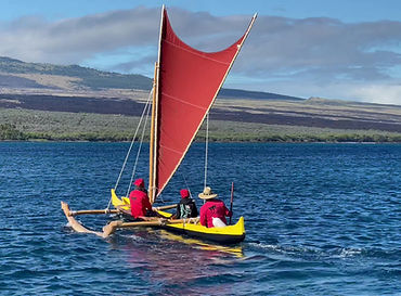
Relating to the Ocean
To the Hawaiian, the ocean is the embodiment of the "akua" Kanaloa. Kanaloa is lord over the winds that blow over the ocean, ocean swells generated by those winds and ocean currents. The very rising and falling of the tides is the inhaling and exhaling of the breath (the "Ha") of Kanaloa. Kanaloa was also the akua of navigation.
The portion of the ocean visible from shore is known as Kai—the familiar, ever-present sea that embraces the land. Beyond the horizon, where the ocean stretches into the unknown lies the Moana—the vast, open ocean.
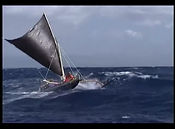
ʻAle are ocean swells that travel great distances across the open sea. In contrast, Nalu are the waves that break upon the shore. Most ocean swells are created by wind blowing across the surface of the water. Unlike waves generated by landslides or earthquakes, these wind waves are formed when the wind, through friction, transfers energy into the ocean’s surface. Importantly, what moves is not the water itself, but the energy traveling through it.
The height and power of a wave depend on three key factors:
-
the strength of the wind,
-
the fetch—or distance over which the wind blows uninterrupted across the water, and
-
the duration of time the wind continues to blow.
The stronger and more sustained the wind, and the farther it travels across the ocean's surface, the larger and more powerful the waves that are formed. These wind-driven waves tend to be choppy, irregular, and lose strength quickly once they leave the area where the wind is blowing.
Because wind does not blow at a constant speed or direction, its gusty nature produces waves of varying speeds and sizes. However, over long distances—hundreds or even thousands of miles—waves moving at similar speeds begin to organize themselves. As they synchronize, they merge into "sets" known in Hawaiian as Haʻanopu.
These swells are no longer reliant on the wind that created them; they carry their own energy, moving steadily across the ocean. Having left the chaotic chop of the storm behind, these swells travel in uniform sets, rolling through the sea with remarkable consistency. These powerful, far-reaching swells are what traditional, non-instrument navigators rely on to guide them across open ocean.
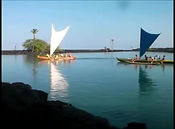
Coastal Navigation
The Ho’okele uses ocean surface conditions to determine the location of reefs, shallow rocks, currents, and other hazards that might threaten the canoe while on a costal voyage. They also use a series of "Land Marks" to note progress and side drift while on a voyage either along the coast or to another island that is visible.
*KUKUI ʻOʻOLOPŪ: Reference points used in steering
Kukui: light (figuratively) guide
O’olopū: to change as in appearance
When traveling from one point to another along a coast or to another island that is visible from the point of departure the Ho’okele uses a variety of orientation points to keep the canoe on course. As the name implies, Kukui ʻo’olopū are not necessarily stationary marks but reference points that are transitional.
Kukui ʻo’olopū can consist of landmarks such as a point of land, notch on a mountain top, a hill, or a dark spot on the landscape. They can be a unique cloud shape on the horizon or the position of the rising sun, moon, or stars.
Kukui ʻo’olopū are not restricted to being located at the front of the canoe or precisely in the direction the Ho’okele is desiring to go. They can be located off to the side and even behind the canoe. Usually, Kukui ʻoʻolopū are used in “clusters” where the Ho’okele uses the relational space between the various points to keep oriented.
It is important to note that when steering a canoe, the shortest distance between the departure and destination points is not always a straight line. Winds, currents, reefs, the direction of ocean swells may all cause a straight course to be the worst course. In fact, keeping a canoe perfectly aligned on any one guide point is extremely difficult if not impossible to do. It is also possible to go off course if the Ho’okele becomes overly fixed on a single landmark or cluster of guide points. (Nana kuli / Hahai ao)
The Ho’okele strives to keep the canoe going in the general direction of the desired destination while making the minimum amount of abrupt turns or drastic course changes to keep on course. Course corrections, in general, should be gradual. It is important that the ho’okele not be transfixed to any single waypoint but continuously be on the lookout for replacement kukui o’olopu as the canoe’s progress makes the original guiding points ineffective or obsolete.
The critical element in keeping a canoe on course is always knowing the direction at which the point of departure is located. The point of departure serves as the basic reference point upon which all future kukui o’olopu derive their usefulness.
Aweawe: wake
The wake of the canoe while underway is very useful in measuring side drift of the canoe caused by wind and or currents. It also helps a Ho’okele judge how straight a course is being kept. The Aweawe is a very important Kukui o’olopu in judging progress and in maintaining a consistent course direction.
.jpg)
Dangers when using Kukui ʻoʻolopū:
Nanakuli:
“Nānā Kuli” literally means “Deaf Watching” or “Blind Observation.”
However, its navigational or figurative meaning is deeper. In the context of wayfinding (ho‘okele wa‘a), Nānā Kuli refers to the practice or danger of “looking but not truly seeing” — when the navigator focuses too narrowly or becomes fixated on one landmark or point of reference and fails to perceive the broader environmental cues (winds, swells, clouds, stars, etc.).
So, depending on context, Nānā Kuli can be interpreted as:
-
“To look without awareness,”
-
“To observe blindly,” or
-
“To fixate and lose true perception.”
It’s often paired with “Hahai Ao” — meaning “to follow the light (cloud or horizon sign)” — the corrective concept of maintaining awareness and responsiveness to changing signs.
Hahai ao:
“Hahai Ao” literally means “to follow the light” or “to follow the cloud.”
-
Hahai = to follow, pursue, or go after.
-
Ao = light, cloud, or day (depending on context).
In the context of navigation (hoʻokele waʻa), Hahai Ao carries a figurative and instructional meaning — it describes the navigator’s practice of staying aware, responsive, and adaptable by following subtle environmental cues such as the play of light on clouds, reflections on the ocean, or other natural signs that indicate direction or changing conditions.
So while its literal meaning is simple — “follow the light/cloud” — its deeper sense is:
“Maintain awareness and adjust to the shifting signs of nature.”
It is often mentioned as the positive counterpart to Nānā Kuli — the state of awareness, responsiveness, and connection to the environment that keeps a navigator balanced and in tune with the living world.
Na Mea Weliweli:
Dangerous Things
Knowing the signs of danger was a Kuleana of every crew member on board the canoe
Kohola – Bare reef at low tide, clearly visible but barely above sea level
Kua Pa’aKua- rock which shows itself then is covered from view as the ocean surface surges. There are usually wisps of white water as the water flows over the reef or rock.
Kai Ko ele Thumping sea: Ocean surface is agitated but there is no white water or white caps. The surface of the water becomes smooth when the ocean surges over the rocks or reef below. It is said that a canoe hull makes a thumping sound when sailing over the reef or rock as the hull strikes the rocks below.
Pu Ko’a Coral head: sunken reef or rock that causes the color of the water directly above to be different color than he surrounding water. Usually the water has a slight brownish or tan color to it. This indicates shallow water. Small canoes can pass over a Pu ko’a safely.
Ke ʻAno Na Makani: wind Conditions
Understanding how strong the wind is blowing and how that wind affects sea surface conditions is critical to not only effectively operating a canoe but ensuring crew safety. . The wind and sea surface categories described in this section are based on traditional Hawaiian sea descriptions.
He'e Nalu: surfing
No other culture is known to have had its survival linked to the surfing ability of its indigenous craft. The Hawaiian canoe had to be able to regularly gain access to life-sustaining deep water marine protein sources. So it was that in Hawaii a relentless siege by surf, with wave forces of up to thousands of pounds per square inch, exercised a classic shaping effect on both the canoe and the culture.
From T. Holmes: The Hawaiian Canoe
Ho'okele: Steering
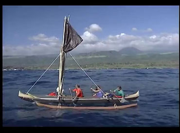
Keeping a round-bottom watercraft on course in choppy seas is no easy task. While being able to visually detect the canoe drifting off course is important, it is even more critical for the steersman to feel the subtle shifts caused by waves and wind as they push the canoe from side to side. This sensitivity allows the steersman to anticipate any deviation before it becomes visible and respond immediately with the appropriate steering stroke.
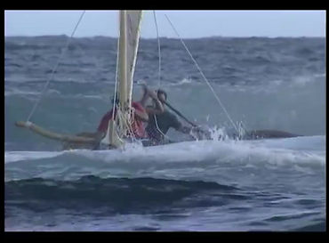
Righting an Overturned Canoe
To minimize loss of life and canoe, "Ke Kama-ihuli-pū, the art of righting upset canoes" was rigorously taught "to the fishermen and the canoesmen of the ancient chiefs of Hawaii. No chief ever sailed the sea carelessly," reported Kaelemakule "without the taking with him some men that were experts in righting a canoe in case they met with an accident at sea."
From T. Holmes: The Hawaiian Canoe

Star Navigation/Wayfinding
Star Navigation uses similar concepts of keeping oriented as is done with costal navigation but is much more complex, It uses the rising and setting points of stars along the horizon in determining course and direction. It also utilizes swell patterns on the open ocean in determining course directions. Both are beyond our capability and we defer to the Pou Naviagtors on this subject.